Login form
Nunavut

The clock struck midnight. Fireworks lit up the sky. The treeless Canadian city of Iqaluit erupted with cheering! Was it New Year’s Eve? No, it was April 1, 1999. People were celebrating the birth of Nunavut, Canada’s newest territory.
Nunavut is Canada’s first territory run by native people. Its capital city is Iqaluit. The creation of Nunavut marked the first change to Canada’s map in 50 years.
A VAST LAND, FEW PEOPLE
Nunavut is located in Canada’s far north, in the Canadian Arctic. Much of it reaches into the Arctic Circle, the area around the North Pole. In fact, about 60 percent of Nunavut lies within the Arctic Circle.
|
Facts About Nunavut |
|
|
|
|
|
Capital |
Iqaluit |
|
Population |
29,500 people |
|
Rank among provinces and territories in population |
13th |
|
Major cities |
Iqaluit, Rankin Inlet |
|
Area |
808,000 square miles |
|
Rank among provinces and territories in area |
1st |
|
Entry into federation |
April 1, 1999 |
|
Provincial bird |
Rock Ptarmigan |
|
Provincial flower |
Purple Saxifrage |
|
Abbreviation |
NU |
Nunavut is bigger than any other territory or province in Canada. It takes up one-fifth of the entire country. Despite its great size, few people live there. That makes Nunavut the most sparsely populated area in Canada.
In addition to Iqaluit, Nunavut contains just a few dozen scattered communities. Some are on Nunavut’s mainland. The rest are on islands that dot Hudson Bay and the Arctic Ocean.
WHY WAS NUNAVUT CREATED?
Nunavut is the native home of Inuit people. In Inuktitut, the Inuit language, Nunavut means “our land.” For many years, the Inuit argued that they had a right to own a part of Canada. After all, their people had lived in Canada long before European settlers arrived.
Eventually, the Canadian government agreed to create Nunavut. In exchange, the Inuit gave up their claims to other traditional lands.
Nunavut was formed by splitting the Northwest Territories into a western part and an eastern part. The eastern part became Nunavut. The western part is still known as the Northwest Territories.
WHAT’S IN NUNAVUT?
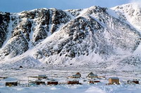
In the west, Nunavut has coastal plains and large, flat plateaus. In the east are jagged, ice-covered mountains. In eastern coastal areas, glaciers have carved deep, narrow bays, called fjords.
Nunavut has many islands in the Arctic Ocean. Some of the islands are huge. One of them, Baffin Island, is the largest island in Canada. Ellesmere Island’s Barbeau Peak, the highest mountain in the Canadian Arctic, rises to 8,583 feet (2,616 meters).
Permanently frozen ground, called permafrost, covers most of Nunavut. In some places, the permafrost is hundreds of feet thick. This makes it virtually impossible to farm. But the territory has vast natural resources that are attractive to mining companies.
A CHALLENGING PLACE TO LIVE
Life in Nunavut can be a challenge. Within the Arctic Circle, the winters are very long, dark, and cold. How cold is it? Winter temperatures can drop to -40º Fahrenheit (-40º Celsius) or lower.
Getting around isn’t easy. No roads or railways connect Nunavut communities. People, along with food and other supplies, must travel by airplane or boat. Sometimes the shipments can’t get through. Frozen seas or Arctic blizzards can stop them.
Because of transportation difficulties, food and supplies are expensive in Nunavut. Many Inuit get much of their food as they always have, by hunting and fishing.
UNIQUE NATIONAL PARKS
Nunavut’s unique national parks are interesting places to visit. Visitors to the parks enjoy dogsledding, mountain climbing, kayaking and canoeing, fishing, and hiking.
Baffin Island’s Auyuittuq National Park Reserve was the first national park within the Arctic Circle. There, you can see the stone remains of houses built by the Thule people. These ancestors of the Inuit arrived in the area some 800 years ago.
Also on Baffin Island is Sirmilik National Park. Sirmilik means “the place of glaciers” in Inuktitut. The park is home to walruses, polar bears, caribou, wolves, seals, whales, and many kinds of seabirds.
Quttinirpaaq National Park is at the far northern end of Ellesmere Island. Quttinirpaaq means “top of world” in Inuktitut. It’s farther north than any other national park in the world. Although it is very cold, Quttinirpaaq is a desert. It receives just a few inches of rain or snow a year, making it one of the driest places in Canada.
Source: Microsoft ® Encarta

