Login form
Ohio River

What was the gateway to the West at the beginning of the 1800s? The answer is the Ohio River. The American West began a lot farther east back then.
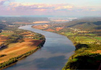
The Ohio River begins in Pennsylvania and joins the Mississippi River at the southern tip of Illinois. It flows for a distance of 981 miles (1,580 kilometers). The states of West Virginia and Kentucky lie to the south of the river, and Ohio, Indiana, and Illinois lie to its north.
There were very few roads in the United States in the late 1700s and early 1800s. No roads crossed the Appalachian Mountains, in the eastern United States. Americans did much of their traveling on rivers. The Ohio River provided a major transportation route for settlers moving west from the Appalachians.
THE NORTHWEST TERRITORY
Pioneers didn’t begin to push beyond the Appalachians until the American Revolution ended in 1783. In 1785, the Northwest Territory was opened for settlement. It consisted of land north of the Ohio River, a region that later became the states of Ohio, Indiana, Illinois, Michigan, and Wisconsin.
Tens of thousands of pioneers clamored for land in the Northwest Territory. They piled their belongings onto flatboats in Pittsburgh, Pennsylvania. That’s where the Monongahela and Allegheny rivers join to form the Ohio. The pioneers floated down the river into the wilderness. They settled in Ohio and Indiana as well as south of the river in West Virginia and Kentucky. The first town in the Northwest Territory—Marietta, Ohio—is on the Ohio River. Marietta became the territory’s first capital.
BEAUTIFUL RIVER
The first Europeans to see the river were explorers and fur traders from France in the late 1600s. The early explorers said Ohio was an Iroquois Indian word that means “beautiful river.” Native Americans lived in the Ohio River Valley for about 10,000 years before European explorers arrived.
THE STEAMBOAT ERA
By the 1820s, steamboats had arrived on the Ohio River. Steam engines powered steamboats. Steamboats moved a lot faster than flatboats, which were pushed along by poles. Traffic on the Ohio rapidly increased as steamboats carried goods and people up and down the river. Three cities became important centers of trade because of their locations on the busy waterway: Pittsburgh, Cincinnati (in Ohio), and Louisville (in Kentucky). Traffic on the river lessened in the late 1800s, after the railroads were built.
THE OHIO RIVER TODAY
The Ohio is still a major transportation route. Millions of tons of coal from mines in Kentucky and West Virginia float by barge to cities downstream. The river is also used to transport farm products, chemicals, and other goods.
By the mid-1900s, the Ohio River had become severely polluted. Sewage and industrial wastes had been dumped in it for many years. No one wanted to swim in the river. Cleanup efforts have helped make the river a place where people can once again enjoy fishing, swimming, and boating.
Source: Microsoft ® Encarta

